2013-12-28

Into the Southern Ocean

Pos: 61°26.531 S, 162°46.472 W
Sea: 3 m
Wind: SW 14 m/s
Weather: Grey

We have crossed the 60° S latitude and are now in what is generally referred to as the Southern Ocean. It comprises all water south of 60° S which encircles the Antarctic continent.


 A quarter of the Southern Ocean. Red squares are our mooring (= underwater stationary instruments) sites, the boat is our current position. Approximately 2300 km to go still.


The Southern Ocean normally has  a depth between 4000 and 5000 m, with the greatest depth being the South Sandwich Trench at 7236 m. The continental shelf area is comparatively deep and narrow, up to 800 m deep. The Southern Ocean  is the source of most of the cold and fresh bottom water for the world´s oceans. It is stongly influenced by the perpetually eastward flowing Antarctic Circumpolar Current (ACC). This is the stongest ocean current anywhere, with 100 times the flow of all the world´s rivers combined.


Jets and eddies in the ACC (from an ocean model)


Pretty soon at around 65° S we will encounter some ice. But most of our moorings, except for one, are in more or less ice free zones, according to the Polar View sea ice map from two days ago. Data is from the Japanese satellite Shizuku


Polar View sea ice map. Moorings are red squares

Today we have been working with our MicroCATs, which will be deployed on the mooring wires measuring Salinity, Temperature and Depth. (see my earlier post "Scientific Background" for more info). The right setups must be configured and they also need a test run in a box of saltwater.


Anna reassembling a SBE 37 IMP

They are very fine (and expensive) instruments made by Sea Bird Electronics. The accuracy of the temperature sensor is +- 0.002 °C. I find it quite remarkable that the battery pack, consisting of 12 Lithium cells with total voltage of 14 V will make it run for three years, taking measurements every 15 minutes in a -2°C environment.


Battery pack (exciting isn´t it?)


Our internet connection is slowly getting weaker. It is now a matter of days until it will be all gone. Hopefully I will be able to do another post. I will end now with the obligatory albatross.


Albatross in the big grey

2013-12-26

Stormriders

Pos: 51°59.041 S, 176°33.404 W
Sea: 1 m
Wind: S 6 m/s
Weather: Sunny

On the afternoon of Dec 24th we hit some quite heavy weather, an easterly wind with gusts over 30 m/s giving swell of about 6 m.


Max wind 27.6 m/s


It´s hard to explain what this feels like. But try to imagine some kind of slow rollercoaster, which moves randomly in all directions. And this ride can of course last several days.


Safe inside


A boat subject to ocean waves will move in response to the waves in six degrees of freedom, defined as surge, sway, heave, roll, pitch and yaw.


Six degrees of freedom


All these movements happen more or less simultaneously. The heaving motion, which happens as the ship is lifted over the top of the wave or carried down into the trough, has the biggest amplitude. Luckily for us the Araon is very stable and the storm didn´t last too long. That night I don´t think anyone slept very good, but on the next day the sea was already beginning to calm down. Now conditions are really pleasant with light winds and sunny weather.


Another albatross


I have learned that telling the different kinds of Albatross apart is really tricky, even for experienced ornithologists. I will thus keep naming all kinds of albatross as just albatross. If you would like to see a map of our route, check out this page by the Swedish Polar Research Sectretariat.

2013-12-24

Leaving land

Pos: 43°53.72 S, 173°36.93 W
Sea: 3 m
Wind: E 12 m/s
Weather: Grey

The Araon is at last on it´s way south now, cruising at 15 knots. My sea legs got tested right away as there is a bit of swell now. No signs of nausea so far, we will see how it goes. 

To mobilize a ship this size takes some effort. A considerable amount of boxes must be loaded onto the ship and brought to their right places.


Counting boxes


Chemistry lab getting organized


It was a relief to finally set off and leave dry land and begin the long journey after all the planning and packing. Quite soon after the departure we were on the big ocean with the 3 meter swell giving Araon some heave. From the aft deck I could watch an amazing air show given by albatross and storm petrels. Being a novice on birds, I haven´t yet figured out what kind of albatross they were.


Leaving New Zealand


The mighty Albatross


It will take us around a week to reach the Amundsen Sea. During this time I suspect we will be quite busy with preparations and planning for the moorings. We need to have a good work plan and all our gear sorted and in good condition to make the retrieval and redeployment of the moorings run as smoothly as possible.

That´s all for now, god jul everyone!

2013-12-22

Forced vacation

The theme of this blog was supposed to be marine science, so please forgive me for posting a few snapshots from my time off on the South Island, New Zealand. I had originally planned to have four days of leisure, which got prolonged to ten days due to the late arrival of Araon. I have really enjoyed my time here, scenic views and unspoilt nature everywhere and very friendly people. 


Arthur´s Pass


Limestone boulder at Castle Hill


West Coast. Nine mile point, WSW 5 ft at 12 s


Rainforest in Paparoa National Park


Essential reading in the campervan


Beware of Penguin


Fur seal lounging at Hickory Bay, Banks Peninsula


The last few days have been spent in Christchurch sorting out the last things before departure. The second city of New Zealand was hit hard by two devastating earthquakes on Sep 4th 2010 and Feb 21st 2011, the latter responsible for the most destruction.


Christchurch cathedral


The city is far from rebuilt with heaps of rubble, scaffolding and containers in many parts. Many of the temporary arrangements are done in a pretty cool artistic and funky manner.

We have had some trouble with the delivery of our equipment, which has not shown up on time. But all our stuff is now in Christchurch and should be in the harbour of Lyttleton tomorrow.


Johan sneaking around in the harbour trying to find our gear


There has also been time to check out Araon, which is now at the dock in Lyttleton. It seems to be a very fine ship, with lots of equipment and spacious areas designated to science. We are all looking forward to set off on our trip, but are also a bit worried if we will be able to run the washing machine. Departure is now set to 12.00 on Dec 24th.


Araon at dock in Lyttleton Harbour


Washing machine on Araon

2013-12-09

Scientific background

Today I will give some basic information about our research and the expedition. Throughout I am aiming to keep my texts here as low-tech and math free as possible.

Where exactly are we going?

Just before Christmas the Korean research vessel icebreaker Araon will depart from Christchurch in New Zealand heading towards the Amundsen Sea. Our main interest is the shelf area, the transitional zone between the deep ocean and the coastal zone. The shelf is around 500 meters deep and there are several deep canyons intersecting it.


Map of our route and the Amundsen Sea

The Araon is 110 meters long, holds 25 crew and 60 researchers and is capable of breaking 1 meter thick ice at a speed of 3 knots. Joining me on this trip will be my supervisor Anna Wåhlin and technician Johan Rolandsson from Göteborg together with our collaborators from Korea Polar Research Institute, Ho Kyung Ha, Sang Hoon Lee and Tae Wan Kim among others.

What are we going to do there?

Basically we will do measurements of salinity, temperature and currents in the ocean. These will be carried out from the ship at different positions, as well as from instruments that are stationary on the seafloor and have been so for several years.

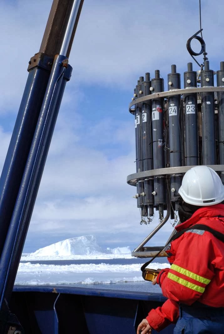
Measurements from the ship are done with a CTD  measuring Conductivity(=Salinity),Temperature & Depth, which is lowered with a crane from the deck. Furthermore there is a ship mounted ADCP (Acoustic Current Doppler Profiler) which continuously measures current speeds.


A CTD with water collectors 


A bottom mounted ADCP

The stationary instruments rigs at the seafloor consist of an ADCP at the bottom and several Microcats (mini CTD:s) at various depths. They are held in place with a big weight at the bottom and a buoy on top and have GPS transponders so we can find them. 


Sketch of bottom mounted rig.

If we manage to find them and get them clear of ice, they will be winched up to the ship, batteries will be exchanged and the measurement data recovered. After service they will be put back down again and left in place until next time around.

 Why are we doing it?

Apart from the fact that this area is one of the least measured and understood in the whole world, the main reason for us to do research in Antarctica is the fast melting of the ice. The major casue for the melting is probably ocean currents. Relatively warm deep water enters the shelf area and melts the glacial ice from below.


Sketch of ice processess

Relatively warm here means that the deep water contains more heat than the upper layers and has potential to melt the ice. The actual temperature is between 1 and 2° C in our area. The speed at which the ice has been melting recently is quite remarkable. This is the fastest melting marine ice anywhere in the world. There are measurements in the area of some glaciers losing up to 9 meters of thickness per year.

As of today we are not really sure why this fast melting is occurring now and if it is set to continue at the current speed or not. The deep currents themselves are influenced by winds. Local winds are in turn subject to large scale climatic oscillations such as El Niño and SAM. Our scientific aims are firstly to be able to better describe how the currents vary in time and space and secondly to do a complete heat budget for this ocean. That means to decide which processes are important in distribution of the heat and calculate how much heat is lost or gained in the parts of the whole system. The heat budget can then be used to assess future changes in this area.

Is it worth it?

I am very grateful to be able to participate in this exciting project. To have marine science as an occupation is something really satisfying. This is all fine for me but why should anyone else care about Antarctica? To put it another way, why should Swedish tax money be spent on research in this far flung place?

The short version to this answer is that very fast changes are occurring and we are not so sure why because this in an area with very few historic measurements. This owes much to the fact that it is a very cold and hostile zone. Most data are younger than 10 years and normally only from summer season. If we can retrieve our moorings, we will have a four year continuous time series, which is one of the longest existing in Antarctica.

The Amundsen Sea is one of three drainage basins (where the ice of the glaciers flows into the ocean) for the West Antarctic Ice Sheet (WAIS), the Ross and Weddell Seas being the two others. The total volume of the Antarctic ice sheet is estimated to 25.4 million km3 of which the WAIS is approximately 10%. If the WAIS should collapse and melt, global sea levels may rise up to 3 meters. Although many of these figures are estimates, there is still reason to be concerned.

Also, if we want to know how the world´s 
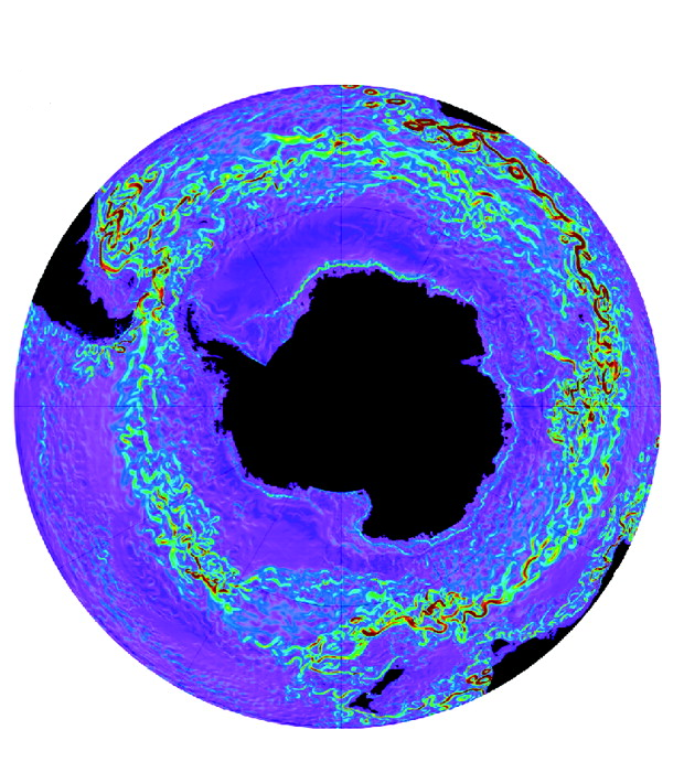
climate works, it is necessary to know about the oceans too. The Southern Ocean which surrounds Antarctica is the main source for cold and heavy deep water, which is an important driver for the global circulation of the world´s oceans. The deep water is distributed to the oceans by the strongest current in the world, the eastward flowing Antarctic Circumpolar Current.


The Antarctic Circumpolar Current


Another argument in favor of Antarctic research, perhaps less directly beneficial to society, is that of scientific curiosity. There are many unanswered questions regarding several things oceanic in this area. The great potential for discovery is in itself a good reason do to research here.

2013-12-03

Heading south soon

On this site I will post reports from an upcoming expedition of the University of Gothenburg to the Amundsen Sea with the korean icebreaker Araon.


Pictures courtesy of Christian Stranne.